Cartography and Geovisualization
Discover the art and science of map production with the cartography and geovisualization certificate from UWEC.
Discover the Art of Map Production
With a focus on cartographic design principles, techniques, and best practices, you'll examine historic and contemporary maps through the lens of their design elements and cultural context. Engage in discussions about the ethics of collecting and analyzing spatial data and learn to apply cartographic visualization fundamentals in the production of various map projects.
You will acquire skills in the art and science of map production through the use and application of geographic information systems (GIS), industry standard illustration software, and online mapping platforms. This certificate is ideal for those who are interested in map production and who wish to develop a complementary set of valuable technical abilities in their area of study.
Program Details

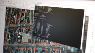
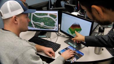
At UWEC, you have the chance to work with the same technology professionals use out in the field today. Learn how to operate equipment such as unmanned aerial systems (UAS), global positioning system (GPS), and ground-penetrating radar (GPR). It’s experiences like these that set Blugolds apart from other candidates when applying for jobs.

The university library is also a federal map depository, with a collection of more than 92,000 maps in its Simpson Map Library, which can be used for research and study.
In addition, the Geography and Anthropology Department has two computer labs dedicated to geospatial science (cartography, GIS, and remote sensing) and is well-regarded for its interdisciplinary work with departments across campus.
Blugold Stories


This 12-credit certificate is designed for students who are interested in learning about the production of maps and their value in communicating visual and written stories. This curriculum provides a solid foundation for those who wish to pursue a graduate degree in a related discipline that benefits from experience in map production and proficiency with varied technology.
Here are a few courses in Cartography and Geovisualization at UW-Eau Claire.
GEOG 280
Introduction to Cartography and Visualization
Introduces the art and science of map production through a focus on cartographic design principles, techniques, and best practices. Historic and contemporary maps are examined through the lens of their design elements and cultural context to inform students as they design maps. Discussions centered on the ethics of collecting and analyzing spatial data provide a critical framework for applying cartographic visualization fundamentals in the production of digital reference and thematic map projects.
GEOG 335
Geographic Information Systems I
This course introduces the basic principles and concepts surrounding the use and application of Geographic Information Systems (GIS). Students will learn how to identify, organize, process, and analyze geospatial data representing geographic features of our world. With the use of state-of-the-art GIS technology, this course makes use of geospatial data representing the environment, economy, socio-cultural, political, and other spheres of our world. Moreover, students will learn how to think spatially, produce maps, analyze geospatial data, and communicate spatial information effectively.
GEOG 339
Applied Cartography and Geovisualization
This advanced map production course integrates cartographic design principles, techniques, spatial and temporal data analysis, and best practices with creative geovisualization products that analyze environmental and societal issues. Dynamic and interactive geovisualization products, including interactive web maps, infographics, and other visual storytelling projects, are emphasized.
Get More Info
Sign up to receive additional information about our campus.


What's Next?